Civil War Maps
![]()
This Site:
Starting a Collection
Top Picks
Online Gallery
Search Page
Order
Winslow Homer
Thomas Nast
Ken Burns Civil War
All Maps are Period Material from the Civil War, taken from original Harper's Weekly Newspapers. Each map is approximately 11x16. I have Many original Civil War Battle Maps not listed on this site. Please email me with your special requests.
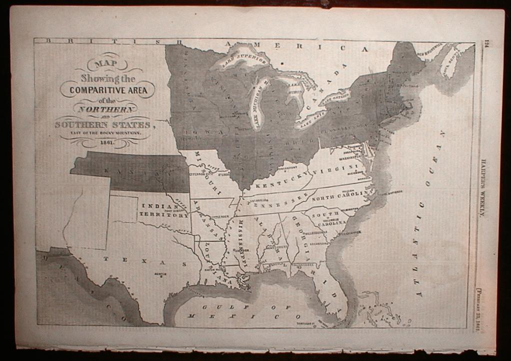
Civil War: Map of the ConflictIt was a war between the states, and this original 1861 map shows it all! This is the most collected of all Civil War maps from Harper's Weekly. It is titled, "MAP Showing the Comparative area of the Northern and Southern States, East of the Rocky Mountains, 1861." |
|
|
This is an awesome map that will make a stunning display when framed and placed in your office or study. It is full of rich historic details. Oklahoma is labeled, "the Indian Territory", and shows Fort Gibson. Northern States are shown in gray, and Southern States are shown in white. The lettering on the map is very ornate. Canada is labeled, "British America". This map is in extra fine condition. h1861p124 Price: $265 |
|
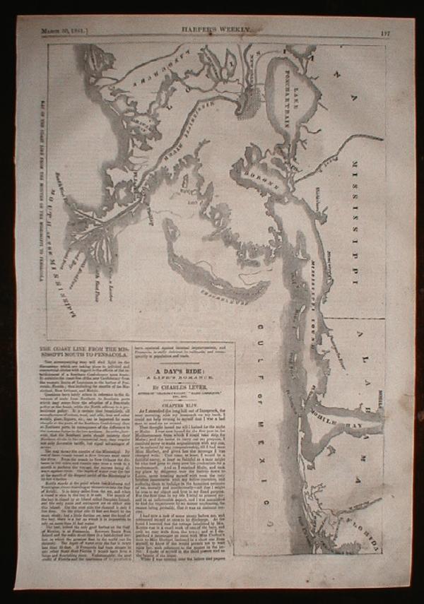
Map of Mobile and New OrleansThis is a nice map from 1861 showing the Gulf of Mexico Coast Line. It includes the Gulf of Mexico, and the mouth of the Mississippi River. It shows parts of Florida, Alabama, Mississippi, and Louisiana. The map has a number of landmarks, including Mobile Bay, Pensacola Bay, Fort Pickens, Mississippi Sound, the Pearl River, Lake Ponchartrain and Timbalier Bay. Inset to the side of the map is a fascinating story titled, "The Coast Line From the Mississippi Mouth to Pensacola". The story starts out, "The accompanying map will shed light on the discussions which are taking place in political and commercial circles with regard to the effects of the establishment of a Southern Confederacy upon trade". The story describes the region as it was at the time. h1861p197 Price: $145 |
|
|
|
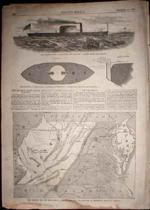
Civil War Battle Map of VirginiaThis is on of the best, original Battle Maps of Virginia to be found. It shows Virginia as it looked in 1861. The map also shows Maryland, and parts of Delaware, North Carolina, Kentucky, and Pennsylvania. The map is captioned, "Map Showing the New Boundaries of Virginia, Maryland, and Delaware, as proposed by Secretary Cameron." The map shows the major rail lines. The print also has a really nice picture and story on the Eriksson Steel-Clad. The print is in very good condition, with area of light foxing in the lower margin. h1861p806 Price: $150
|
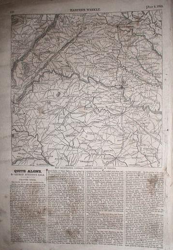
Original Virginia Battle MapThis is a very detailed battle map from 1864 of Virginia. It shows Richmond and the surrounding area, and is captioned, "Map illustrating General Grant's Campaign in Virginia". The print shows details of Wagon Trails, Railroad Lines, and Geographical features. Map covers a fairly wide area, including Hicksford, Fredericksburg, Halifax, Lynchburg, Staunton and Culpeper. A very displayable map with rich historic content. h1864p438 Price: $105
|
|
|
|
Original Fort Sumner Battle MapThis is a very detailed battle map of Fort Sumner printed within days of the start of the Civil War. Given that Sumner was the first battle of the Civil War, this is a particularly important map. Print is captioned, "Map of Charleston Harbor, showing Fort Sumter and the Confederate batteries. Lots of great historic detail including geographic landmarks and positions of the Confederate army. h1861p261 Price: $125 |
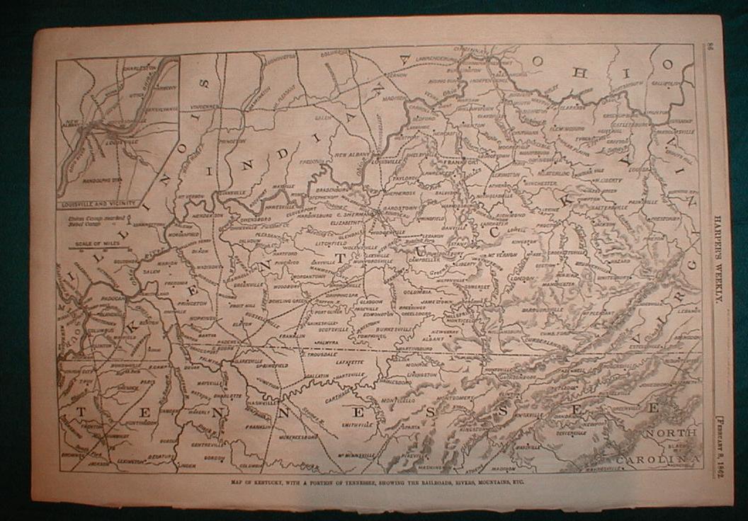
Original Kentucky Battle MapThis is a really nice 1862 Civil War Battle map from the pages of Harper's Weekly. The map shows the entire state of Kentucky, and includes the Northern half of Tennessee, and parts of Illinois, Indiana, Ohio and virginal. The map includes an inset enlargement of Louisville and Vicinity in the upper left of the print. The map includes significant details on the wagon trails and geographical landmarks in the area. This is a highly collectible and displayable print. h1862p86 Price: $125 |
|

![]()
|
Email us at: paul@sonofthesouth.net. Copyright © 2003-2018 Son of the South.
|
|
|
|
Are you Scared and Confused? Click Here to read My Snake Story, a story of hope and encouragement, to help you face your fears. |
||