You are viewing an
original 1862 Civil War Battle Map of Virginia. Please note that this is
NOT a reproduction or facsimile. This leaf is over 140 years old.
On the day it was printed Abraham Lincoln was President of the United
States, and our Nation was in the midst of its bloodiest and darkest
days. It is amazing to hold this leaf, and ponder the way things were on
the day it was printed. As you hold this leaf in your hands, you can
almost hear reverberations of the Civil War in the distance. This is a
rare and dramatic piece that you will not want to miss. Original maps
such as this are becoming increasingly difficult to find as they are being
quickly scooped up by serious collectors and students of history.
Description:
You will simply not find a more dramatic or displayable Civil War map than
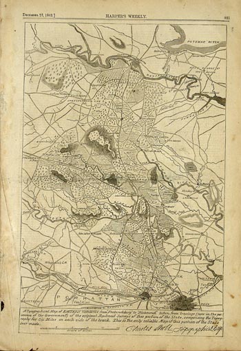
this original Battle Map of Virginia. The Map is captioned "A
topographical map of EASTERN
VIRGINIA from Fredericksburg to Richmond, taken from tracings (now in the
possession of the Government) of the original Railroad Surveys of this
portion of the State, comprising the Topography for Six Miles on each side
of the track. This is the only reliable Map of this Portion of the State
ever made." The map shows Richmond Virginia in the lower part of the
leaf. The Richmond and Danville Railroad Line is shown going through
Richmond, as is the Fredericksburg Potomac Railroad line, and the Richmond
York River line. The James River and Kanawah Canal are shown, along with
coal mines marked west of Richmond. The road used by the Williamsburg
Stage is marked, as is the Bush Hill and Plank Road. The communities near
Richmond shown include Fair Oaks, Mechanicsville, Scottsville and Ashland.
Incredible historical detail on the surrounding area is shown, including
Cedar Swamp, Walnut Grove, the Coal Pits, and Meredith's Bridge. Similar
detail is shown around Fredericksburg, including the Potomac and
Rappahannock rivers. Spotsylvania, King George Court House, Bowling
Green, Negro Foot, Germania, Pottersville, Jericho Marsh, and Sexton's
Junction are shown as well. There is simply too much to describe it all.
You will spend hours pouring over all the incredible detail on this highly
collectible and displayable piece.
Provenance:
This leaf was carefully removed from an original 1862 edition of
Harper's Weekly, the most popular illustrated newspaper of the day.
During the Civil War, Libraries would subscribe to Harper's Weekly. At
the end of the year, they would "bind" the individual newspapers into
large volumes. Fine art, advertisements, Battle Maps, and other
illustrations like this one survived until today in the archives of
Libraries or Historical Foundations. In the 1970's and 1980's, Libraries
microfilmed many of the volumes, and sold the original volumes, filled
with priceless treasures like this one, to the public. I was fortunate
enough to buy a large collection of these volumes when they became
available. Now, I make individual illustrations like the one above
available to individual collectors. Unlike newsprint of this century,
these older, original pages do not yellow and fall apart. The reason is
that modern newspapers use an acid based process. Remnant acid in the
paper causes the paper to quickly yellow and deteriorate. A different
process was used in the mid-1800's which yielded an exceptional quality
paper that will last for centuries. Special acid free mats should be
used when you frame this piece to ensure that it will last another 150
years. Acid free mats are available at most better frame shops. If you
have any questions related to handling or framing this piece feel free
to email me. This leaf is approximately 11X16 inches.
Condition:
The leaf is in very good condition. It has the rich sepia tone that you
expect in original material from this period. It has some light spots of
foxing, consistent with its 140 years of age. There are several
areas of finger smudging in the margins from people handling the leaf
over the last 140 years.The piece is highly displayable, and I guarantee
your satisfaction!
This piece will
make a stunning display when framed and placed in your office or study.
It will become the center of attention, and I assure all who enter will
notice it.
Don't miss your
chance to acquire this truly unique piece of Civil War History. It
would make the ultimate gift for any student of the Civil War, or any
resident of Richmond, or any part of Virginia or West Virginia. I
assure you that this map will become the prized procession of its new
owner, and generations to come.
I Have
Many Original Civil War Illustrations in my Collection, email Me With
Your Special Requests and Questions- I am Here to Help!