Civil War Battle Maps
![]()
This Site:
Starting a Collection
Top Picks
Online Gallery
Search Page
Order
Winslow Homer
Thomas Nast
Ken Burns Civil War
[ Back ] [ Next ]
All Maps are Period Material from the Civil War, taken from original Harper's Weekly Newspapers. Each map is approximately 11x16.
| Map US
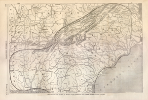
Territory Under Confederate Control This is an excellent map from an original 1862 Harper's Weekly. The map shows the region of the country under confederate control. The map includes most of Kentucky and Mississippi, and all of Virginia, North Carolina, South Carolina, Tennessee, Alabama, Georgia and parts of Missouri, Illinois and Florida. |
|
The map has a dark line around the region controlled by the Rebels. The map has a lot of details, and includes the major cities, Rail Lines and Geographical Land Marks. The Blue Ridge and Cumberland Mountains are pictured. This map is highly collectible, and would make an excellent addition to your Civil War collection. h1862p407 Price: $185 |
|
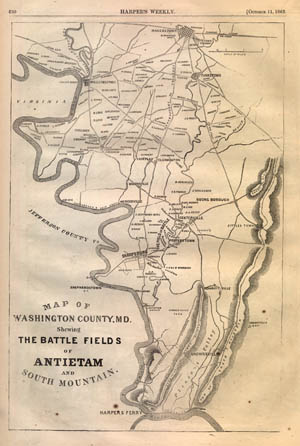
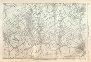
The Battle of AntietamYou are simply not going to find a more historic or collectible map. This is an original map showing the battlefields of Antietam from an 1862 Harper's Weekly. The map includes large ornate lettering which reads: Map Of The map clearly labels the Field of Battle. It shows Centerville, Sharpsburg, Porterstown, Antietam Works, Hagertown, Willimsport, Bakersville, Brownsville, Harper's Ferry, and many many smaller towns. The Potomac River is pictured as it snakes across the map. Map also shows South Mountain, Ely Ridge, Short Hill, and the wagon trails and roads as they were at the time. This is a highly collected and hard to find map h1862p650 Price: $215 |
|
|
|
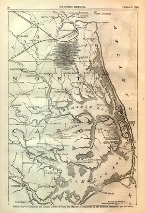
Civil War Map of North Carolina and Virginia CoastlineThis is a dramatic map of the coastline of Virginia and North Carolina from an original 1862 Harper's Weekly. The map is impressive, and will make an awesome display. It includes a significant amount of detail. The map shows Albemarle Sound, Pamlico Sound, Ocracoke Inlet, Hatteras Inlet, Hape Hatteras, Stumpy Point, Neuse River, Palmico River, and Curriluck Sound. The map includes towns and wagon trails in the region. It includes Fort Monroe, Portsmouth, Norfolk, Jerusalem, Sommerton, Elizabeth City, Edenton, Williamston, Plymoth, Newbern, Craneville, Columbus and Hertford. Many smaller towns are also included. The map is captioned, "General Map of Albemarle and Pamlico Sounds, Showing the Theatre of Operations of the Burnside Expedition. This is a really nice map, and one that will look spectacular when framed and displayed. h1862p134 Price: $150
|
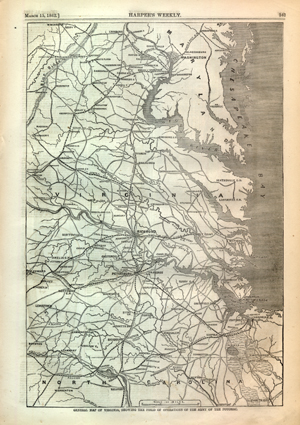
Original Civil War Map of Maryland and Virginia RailroadsThis map shows the Maryland and Virginia Coastline, as well as the Northern part of North Carolina. It is an original leaf from an 1862 Harper's Weekly. This is a really nice map, with lots of interesting details. This map clearly labels all the Railroads connecting the various cities. It includes the Central R.R., Seaboard R.R., the Norfolk R.R., the Norfolk Petersburg R.R., the Petersburg Lynchburg R.R., the Richmond R.R., the famous Danville R.R., the Richmond & York River R.R., the Richmond Fredericksburg R.R., the Orange Alexandria R.R., and the Washington Baltimore R.R. It is incredibly interesting to study all the routes of these earliest of Railroad lines from an original map printed during the Civil War. The map is captioned, "General Map of Virginia Showing the Field of Operation of the Army of the Potomac". There is too much interesting detail to describe it all here. h1862p167 Price: $150 |
|
|
|
Original Civil War Map of MarylandThis is an original map from an 1862 Harper's Weekly. The map is captioned, "General Map of the Seat of War in Maryland". The map includes Washington DC and Georgetown. The map also includes Baltimore and Hagerstown. It labels the Railroad Lines and the wagon trails connecting the cities. Rivers and mountains are also included. You can spend hours studying all the interesting content in this original Civil War map. h1862p614 Price: $150 |
![]()
|
Email us at: paul@sonofthesouth.net. Copyright © 2003-2018 Son of the South.
|
|
|
|
Are you Scared and Confused? Click Here to read My Snake Story, a story of hope and encouragement, to help you face your fears. |
||