Charleston South Carolina


This Site:

The Civil War

Civil War Art

Starting a Collection
Top Picks
Online Gallery
Search Page
Order
Winslow Homer
Thomas Nast
Ken Burns Civil War

Slavery

Civil War Overview

Western Art

Confederate History

Harper's Weekly

Republic of Texas

Revolutionary War

Mexican War


Original 1861 Battle Map:

Charleston South Carolina

Charleston Civl War Battle  Map

Charleston Civil War Map

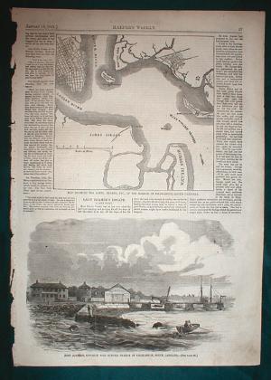
1861 Battle Map of Charleston South Carolina

You are viewing an original 1861 Civil War map of the area around Charleston, South Carolina. It is from the January 19, 1861 edition of Harper's Weekly, the most popular illustrated newspaper of the day. Note that this is not a reprint, and I absolutely guarantee its authenticity. This leaf was printed on January 19, 1861, and this date is clearly marked on the top of the print. On the day this leaf was printed, Abraham Lincoln was president of the United States, and Southern States had seceded from the Union. 

This is a rare and highly collectible map.  The upper image on the leaf shows the city of Charleston, and the surrounding area.  It is captioned, "Map Showing the Forts Islands, Etc. of the Harbor of Charleston, South Carolina".  The map shows a nice view of Charleston as it appeared at the opening of the Civil War.  Also pictured are the Cooper River, Ashley  River, and the Main Ship Channel in the Harbor.  The map also includes Hog Island, Mount Pleasant, Castle Pinekney, James Island, Fort Johnson, Morris Island, Fort Moultrie, and Cumming's Point.  Most importantly, in the center of the harbor, is Fort Sumter, where the opening shots of the Civil War were fired.

The lower illustration shows a nice view of Fort Johnson, Opposite Fort Sumter.  This shows a lots of detail on how the fort looked at the opening of the civil war.  Also pictured are a couple in a row  boat in the harbor.  Several soldiers are pictured in the fort.

This is a highly collectible piece.  The illustration is important in that it shows a view of the Fort Sumter area just days before the opening shots of the war were fired there.  The map would make an excellent addition to your collection.  It would make a wonderful gift for anyone living in the Charleston area, or anyone interested in the the Civil War.

Unlike newsprint of this century, these older, original pages do not yellow and fall apart.  The reason is that modern newspapers use an acid based process.   Remnant acid in the paper causes the paper to quickly yellow and deteriorate.   A different process was used in the mid-1800's which yielded an exceptional quality paper that will last for centuries. Special acid free mats should be used when you frame this piece to ensure that it will last another 150 years.  Acid free mats are available at most better frame shops.  If you have any questions related to handling or framing this piece feel free to email me. The print is approximately 11x16  inches.  I have been collecting Civil War Newspapers for over 10 years.  It is a fascinating hobby, and I find that these pieces really get noticed when framed and displayed.

The leaf is in very good condition. It has the rich sepia toning that you expect in original material from this period. It has a few spots of light foxing and a few finger smudges in the margins.

Up | Charleston South Carolina | Fort Sumter | The San Antonio Plaza | Norfolk Virginia | Montgomery Alabama | Point Comfort Virginia | Fort Taylor | Fort Smith and Little Rock | Key West Florida | Fort Sumter | New Orleans and Mobile Alabama | Pensacola Florida | Charleston South Carolina | Fort Pickens | Halltown Virginia | Harrisburg Pennsylvania | Camp Cameron | St. Louis | Cairo Illinois | Jefferson City Missouri | Fort Pickens


 Email us at: paul@sonofthesouth.net

Copyright © 2003-2018 Son of the South.

privacy policy


Are you Scared and Confused? Click Here to read My Snake Story, a story of hope and encouragement, to help you face your fears.