|
This Site:
Civil War
Civil War Overview
Civil War 1861
Civil War 1862
Civil War 1863
Civil War 1864
Civil War 1865
Civil War Battles
Confederate Generals
Union Generals
Confederate History
Robert E. Lee
Civil War Medicine
Lincoln Assassination
Slavery
Site Search
Civil War Links
Civil War Art
Mexican War
Republic of Texas
Indians
Winslow Homer
Thomas Nast
Mathew Brady
Western Art
Civil War Gifts
Robert E. Lee Portrait
|
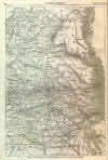
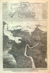
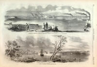
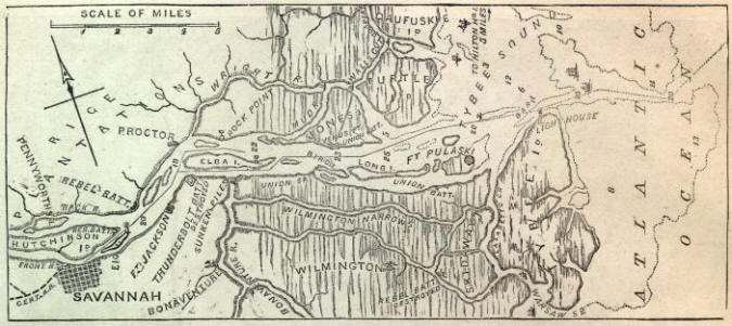
APPROACHES TO
SAVANNAH.
THE accompanying Map shows
clearly the approaches by water to Savannah, which is situated on the south bank
of the Savannah River, about eighteen miles from the Atlantic Ocean by the
channel of the river, as indicated by a line on the Map. The depths of the
channel, at low tide, are given in feet, the outer dotted line representing
eighteen feet. It will be seen that Fort Pulaski commands the bar and channel of
the river, also other water approaches, which, however, are shallow. From
Hilton Head Island the United States forces
passed through Cooper River, Wall's Cut, Mud and Wright rivers, into the
Savannah River, and built forts on Jones and Bird's islands, which cut off
supplies by water from Savannah to Fort Pulaski. Another base of operations is
Warsaw Sound, south of
Tybee Island, from which
light-draught vessels pass into
Wilmington Narrows, and thus command the land approaches to Fort Pulaski. The
land being low and marshy, the cannon and mortars of the Union gun-boats have a
range for miles over the banks of the streams. A wooden road has been made over
the miry land of Jones Island, from the end of Wall's Cut to Venus Point, where
has recently been built a strong battery commanding the river, and putting a
stop to the operations of "Commodore Tatnall's Mosquito Fleet." The naval firing
between Commodore Tatnall and Captain Davie was when the boats of the former
were in the Savannah River, and those of the latter in Wilmington Narrows.
Sunken piles prevent our boats
passing from Wilmington Narrows to the Savannah River. The Skidaway and
Thunderbolt batteries, built by the rebels, have been destroyed by our
gun-boats.
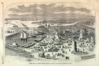
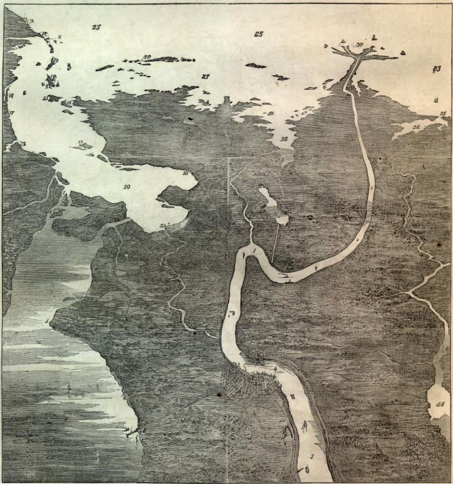
1. Mississippi River.—2. NEW
ORLEANS.—3. Algiers.—4. Lake Pontchartrain.—5. Point aux Herbes.—6. FORT
PIKE.—7.Rigolets.—8. FORT MACOMB and Menteur Pass.—9. Pine Island.—10. Lake
Borgne.—11. Pearl River, boundary between Louisiana and Mississippi.—12.
Malheureux Islands.—13. Shieldsborough.—14. St. Joseph's Island.—15. Cat
Island.—16. SHIP ISLAND, in possession of the Federal Government.—17.
Mississippi City, in possession of the Federal Government.—l8. Biloxi, in
possession of the Federal Government.—19. Pascagoula.—20. Horn Island.—21.
Mobile.—22. Fort Morgan.—23. Fort Pickens.—24. Pensacola.—25. Gulf of
Mexico.—26. Chandeleur Islands.—27. Chandeleur Sound.—28. Black Bay.—29. FORT
DUPRE.—30. Mouths of the Mississippi.—31. FORT JACKSON.—32. FORT PHILIP.—33.
Fort Livingston.—34. Barataria Bay.—35. FORT LEON.—36. Woodville and Canal.—37.
Lake Lery.—33. Proctorville and Fort.—39. FORT BIENVENUE.—40. Bayou Bienvenue.—41.
New Orleans and Lake Pontchartrain Railroad.—42. New Orleans and Jackson,
Mississippi, Railroad.—43. Carrollton.—44. Lake Washa.
BALLOON VIEW OF THE VICINITY OF NEW ORLEANS,
LOOKING TOWARD THE GULF OF MEXICO.
|