|
This Site:
Civil War
Civil War Overview
Civil War 1861
Civil War 1862
Civil War 1863
Civil War 1864
Civil War 1865
Civil War Battles
Confederate Generals
Union Generals
Confederate History
Robert E. Lee
Civil War Medicine
Lincoln Assassination
Slavery
Site Search
Civil War Links
Civil War Art
Mexican War
Republic of Texas
Indians
Winslow Homer
Thomas Nast
Mathew Brady
Western Art
Civil War Gifts
Robert E. Lee Portrait
|
(Previous
Page) feet high, and a foot and a half
through, in shape as near as can be described to a well-formed pear, with an
iron cap fastened by eight screws. Taking off the cap we found grape, canister,
and four eight-pound shell, surrounded by about two bushels of coarse powder. On
the bottom of the cask there was a wooden box containing several batteries, with
hollow wires attached to two larger wires, covered with a substance impervious
to water, connecting with the cavern before spoken of. A dozen of these iron
pots or casks were thus united with this cavern. Half a dozen of these caverns
have been found, and probably 75 or 100 of these infernal machines are thus
buried in the earth, some distance from the enemy's works; and the time to be
exploded would be when our infantry had driven them inside their works—a
sentinel would give the operator inside the cavern a signal, and he would send
the electric spark through all the wires, and decamp. The result may be
imagined. Whole regiments could thus be blown up and sent to eternity, without
even a chance of escape. The discoveries, as far as made, are all on the north
and northeast portions of their works, Probably other parts of the works are
similarly mined. Fortunately their fiendish designs were discovered in time, and
no damage has been done by soldiers, who are constantly on the look-out for
discoveries, and might by accident have set off the train.
Another class of infernal
machines, called torpedoes, have been discovered anchored in the river. They are
round, about three feet long and a foot and a half in diameter, with one end
tapering off to a point. The river is very high, and the number can not be made
out. It took three steamers five days to sink what are in the bottom of the
river. The very high stage of water has prevented any damage to either gun-boat
or transport.
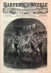
A THRILLING SCENE IN
TENNESSEE.
WE illustrate on
page 193 a
thrilling scene which took place in Eastern Tennessee in connection with the
recent uprising of Union men in that region of country. We take the following
account from the Knoxville Register of February 8.
The facts connected with the
burning of the Lick Creek Bridge; as they appeared in the testimony elicited by
the Court-martial, have come into our possession from an authentic source, and
are as follows:
A man by the name of David Fry,
in connection with William B. Carter, both citizens of East Tennessee, but who
had lately deserted the land of their birth, fled to Kentucky, and connected
themselves with the enemies of their country, returned to East Tennessee after
the repulse of
General Zollicoffer's command at Rockcastle Hill, for the purpose
of inciting a conspiracy with the traitors on this side, which would result in
the entire destruction of the railroad facilities here, and then break up and
entirely cut off communication between Virginia and the remaining
States of the
Confederacy, prevent the transportation of troops, provisions, and munitions of
war, and thus open the way for the successful invasion of our State. These two
men, as is supposed, came first into the county of Anderson, and then, concealed
at the house of a Union man, sent, as one of the witnesses heard, for William
Pickens, of Sevier, who made the attempt upon Strawberry Plains Bridge, but who,
with his gang of fifteen men, was repulsed by Keelan single-handed and alone,
Pickens himself falling seriously wounded.
It is known that Fry and Carter
passed on into Roane County, and parted at Kingston. At this point we lose sight
of Carter, as no evidence has yet appeared of his whereabouts after that time.
Fry, however, proceeded on his journey up the country, passing through Loudon
(no doubt making every arrangement for the destruction of that bridge), then
passing through Blount County, and finally reaching Greene County two days
before the burning of Lick Creek Bridge.
Traveling, as he did, at nights,
and lying by in day-light, stealthily and treacherously creeping from one
traitor's house to another, his movements could not be traced until he arrived,
on the night of Wednesday, the 6th of November, at the house of Anderson Walker,
in Greene County. Here he remained until the night of Thursday, the 7th, when he
proceeded to Martin Walker's, arriving about eight o'clock at night. At Martin
Walker's he met his wife, and remained until two o'clock in the moaning of the
8th, stating to Walker that he was on his way to Kentucky, but wanted to see a
friend near Midway (Lick Creek Bridge), and asking if Jacob Harmon was as good a
Union man as ever. As appeared from the testimony, Fry made no revelations to
Walker of his plans; but starting, as he did, at two o'clock, and not being
familiar with the roads, Walker piloted him about three miles in the direction
of Midway.
After leaving Walker, Fry stopped
at the house of Daniel Smith, a noted Union man, living five or six miles from
the bridge, arriving there about one hour before daylight. Immediately Fry laid
his plans before Smith, who agreed to act as a messenger from Fry to Jacob
Harmon to communicate to Harmon that he (Fry) was at Smith's house; that he had
come to destroy the railroad, and that he wanted to see Harmon at Smith's house
that morning. This message was communicated by Smith to Jacob Harmon about eight
o'clock on the morning of the 8th of November; and accordingly Harmon, who was a
leading Union spirit in the neighborhood, repaired to Smith's house, where the
plans were unfolded, and the plot and programme agreed upon. Harmon was to go
home, circulate the fact throughout the neighborhood, and gather the Unionists,
assembling them at his house on that night, while Fry would remain at Smith's
until nightfall, and then repair to Harmon's house to consummate the conspiracy.
Harmon did his share of the work
well, for as early as nine o'clock at night between thirty and forty
conspirators had met at his house, ready to be led by their chief on his
arrival, and eager for the destruction of the property. At that hour Fry
alighted from his horse and bounded into the yard, exclaiming: "Friends, I am
Colonel Fry, and am come to share with you." The party immediately assembled in
the house, when Fry commenced haranguing the crowd by revealing his plans, and
urging them on to deeds of violence, until the crowd were almost unanimous in
their expressions of approbation, and with one accord determined that the bridge
should be destroyed—that Fry should be their leader, and that they would follow
him, if necessary, to death.
Fry drew forth a
United States
flag, and spreading it upon a table in the centre of the room, called upon his
followers to surround that emblem of the Union, and take with him the oath of
allegiance. This was late in the night; and after the whole plot had been fully
understood, the conspirators surrounded the table in groups, and, by direction
of the leader, placed their left hands upon the folds of the flag, raising aloft
their right hands, and swearing to support the Constitution of the United
States, to sustain the flag there spread before them, and to do that night
whatever may be impressed upon them by their chief. This oath was taken by all,
except two or three, in solemn earnest, and in silence; the darkness relieved
alone by the dim and flickering light of a solitary candle. The scene was
impressive—the occasion was full of moment—the hour was fit, and every thing
conspired to fill the hearts of the traitors with a fixed determination.
Aroused thus to the highest pitch
of malice and revenge, the chief of the conspirators immediately led the way to
the bridge, and was followed in eager haste by the willing crowd. The
Confederate guard, consisting of five soldiers, watching the bridge, were
immediately surrounded by the infuriated mob, and were held in close
confinement, while Fry, still leading the way and still followed by the boldest
of his clan, hastened to the wooden structure, applied the torch, and the whole
was consumed and burned to the ground in an hour.
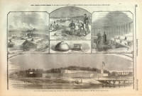
FORT CLINCH, FLORIDA.
OUR special artist, Mr. Theodore
R. Davis, has sent us sketches from the recent expedition under Commodore
Dupont, one of which, representing
FORT CLINCH, Florida; the first of the forts
repossessed
by the United States forces, we
reproduce on page 198.
Commodore Dupont reported to the
Navy Department regarding Fernandina and its defenses:
The towns of St. Marys and
Fernandina are uninjured. I visited the town, Fort Clinch, and the earth-works
on the sea face of the island. It is impossible to look at these preparations
for a vigorous defense without being surprised that they should have been
voluntarily deserted. The batteries on the north and northeast shores are as
complete as art can make them. Six are well concealed and protected by ranges of
sand hills in front, contain a perfect shelter for the men, and are so small and
thoroughly covered by the natural growth and by the varied contours of the land,
that to strike them from the water would be the mere result of chance. A battery
of six guns, though larger, and affording therefore a better mark, is equally
well sheltered and masked. These batteries, and the heavy guns mounted on Fort
Clinch, command all the turnings of the main ship channel, and rake an
approaching enemy. Besides them there was another battery of four guns mounted
on the south end of Cumberland Island, the fire of which would cross the channel
inside the bar. The difficulties arising from the indirectness of the channel
and from the shoalness of the bar would have added to the defenses by keeping
the approaching vessels a long time exposed to fire under great disadvantages;
and when the ships of an enemy had passed all these defenses, they would have to
encounter a well-constructed and naturally masked battery at the town, which
commands the access to the inner anchorage. We are told that General Lee
pronounced the place perfectly defensible. We are not surprised at this, if
true. We captured Port Royal, but Fernandina and Fort Clinch have been given to
us.
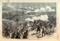
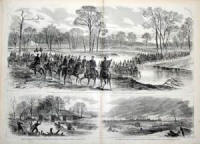
THE ADVANCE OF THE GRAND
ARMY INTO VIRGINIA.
WE devote
pages 200, 201, and
204
to illustrations of the
ADVANCE OF THE GRAND ARMY OF THE POTOMAC, UNDER GENERAL
McCLELLAN, INTO THE REBEL STATE OF VIRGINIA. Our pictures are from sketches by
Mr. A. R. Waud, who accompanies the army. One of the sketches on page 200
represents the BRIDGE OVER
BULL RUN, near Blackburn's Ford, where some hard
fighting took place on 18th July, 1861. It will be well remembered by the three
months' troops. The large picture above shows us GENERALS McCLELLAN AND McDOWELL
CROSSING BLACKBURN'S FORD with an escort of two thousand cavalry. The
correspondent of the Philadelphia Inquirer thus describes the crossing of
Blackburn's Ford:
About noon Generals
McClellan and
McDowell, with their staffs, and two thousand cavalry for an escort, came up and
took the road to Manassas. We fell in with them and followed on down to
Manassas. All along to the left of the road was one continuous string of huts,
tents, and forts, all empty now—not a human being or animal showed
themselves—not a sound save the clatter of the horses' hoofs, the shrill tones
of the bugles, or the loud orders of the officers.
At Blackburn's Ford we saw the
old battle-field of July 18. The Butler House, which was between the two forces,
and had been riddled with shot and shell, has been repaired. It was here
Beauregard was dining, and made such a narrow escape at the time. The tree tops
bear the evidence of the way the shot and shells flew around. Large limbs were
cut off, and tree tops twisted in a hundred directions, as though struck by
lightning. The woods in which the New York Twelfth, the First and Second
Michigan, and the Massachusetts First went down has all been cut away, and we
can now see where the rebels had their artillery, upon the bank of Bull Run,
behind a breast-work of logs and dirt.
The Washington Artillery of
New
Orleans and three South Carolina regiments have been encamped near the Butler
House for the winter, but started away some time ago. The artillery left a
quantity of harness, etc. None of their tents were destroyed. Further down are
the tents of a whole division, all pitched, as though the occupants had gone
home to recruit and re-enlist, but had not yet returned.
The Plains of Manassas are really
what their name implies. The time was when there were objects which obstructed
the range of vision, but they are all gone now; for miles around we have an
unbroken view. On the hills around are the camps still left, and a column of
smoke away off to the right indicated that Manassas was on fire. Our cavalry had
gone there during Monday night, and found the rear of the enemy still there; but
they were firing the remaining property. A captain, by whose side we rode, told
us of piles of new secesh clothes, swords, flags, etc.; galloping ahead of the
rest, we reached the Junction. The sight here can not be portrayed; the large
machine shops, the station-houses, the Commissary and Quarter-master
store-houses, all in ashes. On the track stood the wreck of a locomotive, and
not far down the remains of four freight cars which had been burned; to the
right, five hundred barrels of flour had been stove in, and two hundred barrels
of vinegar and molasses had been allowed to try experiments in chemical
combinations. Some fifty barrels of pork and beef had been scattered around in
the mud, and a few hundred yards down the track a dense cloud of smoke was
arising from the remains of a factory, which had been used for rendering up
tallow and boiling bones. About a thousand good hides were stretched in a field
close by upon stakes, and remain uninjured.
On the same page a small picture
illustrates the EVACUATION OF MANASSAS
JUNCTION
BY THE REBELS, and the burning of their huts—a dreary, dismal scene. All the
correspondents concur in saying that it was desolation intensified. Every thing
the rebels could not readily carry away they destroyed, burning houses, clothes,
and stores of all kinds, and rendering the place a perfect wilderness.
On page 204 we illustrate the
INTERSECTION OF THE ORANGE AND ALEXANDRIA RAILROAD WITH THE MANASSAS GAP LINE.
This is the "Junction" which has given its name to the spot, and which imparted
to the place so much military importance. The possession of the Junction gives
us command of both roads.
The same page contains a general
view of CENTREVILLE, showing the rebel Winter Quarters there, mostly in flames
and ashes. On one side will be seen a fort which formed the key of their works.
In the distance is the Bull Run battle-field; and further yet may be seen the
Blue Ridge, with the fires which mark burning bridges and homesteads in flames.
Desolation on every side.
It appears that every thing which
the rebels could destroy in their retreat was consumed. The store-houses at
Manassas, with a large quantity of flour, were burned, and the Warrenton
Station, together with the hotel and five or six dwellings. The bridge over
Cedar Creek, two miles north of Warrenton, was burned down, and a freight train
of fifty-two cars, loaded with commissary stores worth $20,000, was set on fire
at Thoroughfare Station, twelve miles from Manassas, on the road to Winchester,
but were rescued from destruction by our troops before they were consumed.
Mr. Waud will continue to
accompany the army under General McClellan, and will illustrate every event of
note for Harper's Weekly.
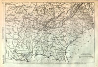
MAP OF THE SOUTHERN
STATES.
IN order to enable our readers to
understand the oft-repeated expression of the "Anaconda" tightening its folds
round the rebels, we publish a general
MAP of the seat of the rebellion on
page
199, showing the relative position of the rebel and the Union forces. Sixty days
ago those positions were very different. Then the rebels held half of Missouri,
nearly half of Kentucky, and Eastern Virginia to the Potomac. Their present
retiring line is seen on the Map, whose author writes as follows concerning it:
The Map on page 199 represents
the region of SECESSIA, with all its railroad communications and principal
rivers; also the present position of the Union and rebel forces. By reference to
the Map it will be seen that some railroads are of great importance in
concentrating rebel military forces to oppose the progress of the Union armies,
and in facilitating the movements of the traitorous soldiers in their retreats
from merited chastisement. The railroad through Western Virginia and Eastern
Tennessee is a very important one, communicating at Lynchburg with the railroads
of Eastern Virginia and North Carolina, and connecting at Chattanooga with the
extended railroads of North Alabama, Mississippi, and West Tennessee; while at
Dalton it connects with the railroads of Georgia, South Carolina, the railroads
and navigable waters of Alabama. With this railroad in the possession of our
forces soon to be at
Knoxville, the rebel army recently at Manassas can not
retreat to the mountainous region of Chattanooga, Stevenson, Cleveland, and
Dalton; which region, for defense in a desperate struggle, is the strongest in
the Southern States. Memphis, Corinth, Mississippi; Knoxville and Chattanooga,
Tennessee; Dalton, Atlanta, Augusta, Georgia; Goldsborough, North Carolina;
Lynchburg and Richmond, Virginia, may be noted as very important points in the
railroad communications of the Southern States. By the Map, on which the line of
Union forces is represented, it will be observed how these important places are
menaced by the different divisions of our armies in motion.
The victorious army under General
Curtis having scattered the united rebel forces west of the Mississippi, has
command by this time of the navigable rivers of Arkansas. Using the Arkansas
River, nature will carry his army to the rear of Memphis, or to unprotected
Vicksburg, Natchez, and the Lower Mississippi at the proper time. The victorious
General Pope, by the same law of gravitation, can move toward Memphis from the
north, at the time
General Grant and his heroic troops move up the Tennessee
River, and, reducing Savannah, march overland westward to
Memphis.
General Buell
and his powerful army have their front toward Northern Alabama and Northwestern
Georgia.
General Fremont is preparing to put the army of the Mountain Department
in motion as soon as the weather in those elevated regions will allow. General
M'Clellan, with his splendid and disciplined army, is in motion after the
retiring army of rebels which expected to have passed the winter in Baltimore
and Philadelphia, and to have been paid in New York. As that intention has not
been allowed to the accidental victors of Bull Run, they may not speculate on
where they will pass the spring and summer, and what pay they will get. General
Burnside is at work in the rear of Norfolk, Weldon, and Goldsborough.
General Sherman is occupying a
strong force of the rebels to protect Savannah and Charleston. Brunswick,
Georgia, Fernandina, and Cedar Keys, Florida, Fort Pickens, and Ship Island are
ours as bases for other operations; and probably before the next issue of our
Weekly something will occur near Ship Island which will make a report to be
heard throughout the country, and a shock which will be felt as far north as
Richmond.
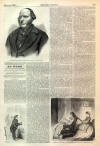
CAPTAIN ERICSSON.
ON
page 205 we give a
portrait of
CAPTAIN ERICSSON, the inventor and builder of the Monitor,
of which we give below some
diagrams. The following is a sketch of his life :
John Ericsson was born in 1803,
in the province of Vermeland, among the iron mountains of Sweden. His father was
a mining proprietor, so that in his youth he had ample opportunities to watch
the operations of the various engines and machinery connected with the mines.
In 1814 he attracted the
attention of the celebrated Count Platen, who had heard of his boyish efforts,
and de-sired an interview with him. After carefully examining the various plans
and drawings which this youth exhibited on this occasion, the Count handed them
back to him, simply observing, in an impressive manner, "Continue as you have
commenced, and you will one day produce something extraordinary." These few
words of kind encouragement from so distinguished a personage sunk deeply into
the mind of the young mechanician, and confirmed him in the career on which he
had entered. Immediately after this interview young Ericsson was appointed a
cadet in the corps of engineers; and after six months' tuition, at the age of
twelve years, was appointed nivelleur at the Grand Ship Canal of Sweden, which
connects the North Sea with the Baltic, under Count Platen. In this capacity, in
the year 1816, he was required to set out the work for more than six hundred
men, and at that time he was not tall enough to look through the leveling
instrument, and in using it he was obliged to mount upon a stool, carried by his
attendants for that purpose. As the discipline in the Swedish army required that
the soldier should always uncover his head in speaking to his superior,
gray-headed men came, cap in hand, to receive their instructions from this mere
child. There are now many important works on the canal constructed after
drawings made by Ericsson at this early age. At the age of fifteen he was in
possession of accurate plans of the whole work, drawn by his own hand. His
associations with military men on the canal had given him a tendency for
military life, and at the age of seventeen he entered the Swedish army as an
ensign. About this time the Government had ordered the northern part of Sweden
to be surveyed, and that officers in the army should be employed in this
service. Ericsson, whose regiment was stationed in the Northern Highland, was
appointed on the survey. There are yet in the archives of Sweden detailed maps
of upward of fifty square miles made by his hand.
While thus variously occupied,
being on a visit to the house of his Colonel, Ericsson on one occasion showed
his host how readily and by what simple means mechanical power may be produced,
independently of steam, by condensing flame. On the 18th of May, 1826, he
obtained permission from the King to visit England. In the fall of 1829 the
Liverpool and Manchester Railway Company offered a prize for the best locomotive
engine, to be tested on the small portion of the railway then completed.
Ericsson, not willing to allow this occasion to escape him, immediately set to
work, planned the engine, executed the working drawings, and caused the patterns
to be made, and the whole machine was completed within seven weeks. The day of
trial arrived. The competing engines were on the ground, and the novelty of the
race had attracted an immense concourse of people. Both sides of the railway,
for more than a mile in length, were lined with thousands of spectators, and to
the surprise and admiration of the crowd, the Novelty steam-carriage started,
guided by its inventor, Ericsson, assisted by John Braithwaite, and darted along
the track at the rate of fifty miles an hour. Mr. Ericsson was the first to
apply to marine engines centrifugal blowers, now so common in this country in
all boilers using anthracite coal. In the year 1831 he applied such a blower,
worked by a separate small steam-engine, to the steam-packet Corsair, of
120-horse power, plying between Liverpool and Belfast.
Mr. Ericsson emigrated to this
country in 1839, then being thirty-six years old. His first great achievement
after his arrival was the building of the United States steam-frigate Princeton,
the first vessel that steam was ever introduced into with the works below the
water-line. She proved a complete success. About the same time he planned the
French frigate Pomone, fifty guns, which is at present in our waters; she also
proving a great success. Captain Ericsson, after the completion of these
vessels, gave his whole time to his favorite work, the completion of the caloric
engine, which he has since brought to great perfection, though on a small scale.
His next undertaking was the planning and invention of the steamer Ericsson,
which is familiar to all our readers. He did the whole work, from the time her
keel was laid to the moment that her paddles were first turned, in the brief
space of seven mouths. Although not answering all that was commercially expected
of her, she was an entire mechanical success, speaking more than words of the
great genius of the inventor, and as a marine structure she has never been
equaled, much less surpassed. The name of Captain Ericsson has been
comparatively unheard of for some time past, until the commencement of another
new idea of his, as illustrated so satisfactorily in the new noble steam-battery
Monitor. He signed the contract for her construction on the 5th day of last
October, and on the 31st of December—being a period of two months and eight
days—her steam, machinery, and propeller were put into operation, and on the one
hundred and first working day she was launched. This is a celerity which has
never been equaled in this country or in England.
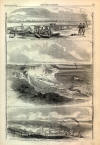
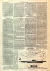
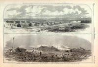
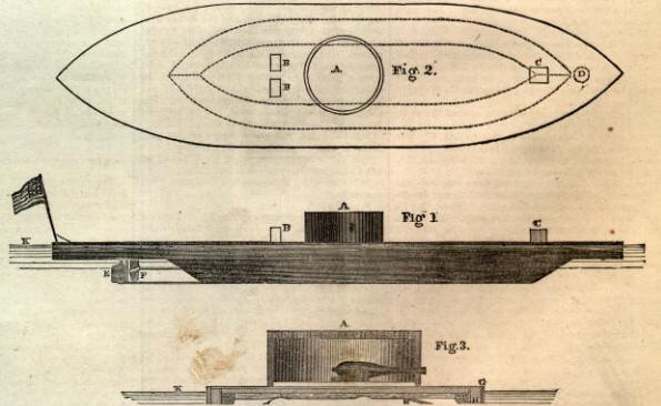
THE "MONITOR."
To the views which we have before
given of the Monitor we now add three plans. They give a more perfect idea of
her construction than any thing which has been published. Figure 1 represents
her as launched and ready for action; Figure 2 is a plan of her deck; and Figure
3 is a cross section cut down through the turret. The black line in Figure 1
above the water-line shows precisely how much of her body appears above the
water.
A. Revolving Turret.—B. B. Smoke-pipe.—C, Pilot-house.—D, Anchor Well.—E,
Rudder.—F, Propeller.—G, Iron Armor.—H, Braces for Deck Beams.—
K, Water-line.—L,
Dahlgren Gun,—M, Gun-carriage.
|