War in Virginia
|
|
This Site:
|
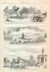
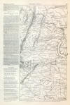
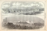
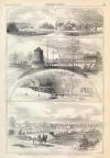
SEPTEMBER 13, 1862.] HARPER'S WEEKLY. 583 MAP OF THE SEAT OF WAR IN VIRGINIA, SHOWING THE SITES OF THE RECENT BATTLES. (Previous Page) chalybeate springs which have been discovered in the vicinity, and which possess medicinal virtues. Brigadier-General R. B. Mitchell has established his head-quarters at Iuka, and the several regiments of his brigade are stationed near, either guarding the railway or protecting the town from rebel attacks. THE SCENE OF WAR IN VIRGINIA.ON page 580 we give a picture of CENTREVILLE, Virginia, to which General Pope's army withdrew on the evening of 30th, after a severe battle with General Jackson; and on the same page, a picture of the intersection of the Orange and Alexandria Road with the Manassas Gap Railroad, which was the scene of a sharp skirmish last week. We give also, on page 583, a MAP OF THE SEAT OF WAR IN VIRGINIA. This map will be better understood by perusing the following topographical information from the Tribune: 1) West Virginia, lying westward and south-westward of the crests of the Allegheny mountains, which traverse the State from northeast to southwest in an unbroken chain, rising from 2000 to 4000 feet above the ocean level, and of course nowhere perpetually snow-covered or impassable, though the roads which cross them are narrow and bad, two or three great turnpikes excepted. The Baltimore and Ohio Railroad crosses them at this end of the State, and is held by the Unionists; nearly all the other railroads whereby the State is amply gridironed are (save for a few miles around Washington) in the hands of the traitors. West Virginia is almost unanimously free-labor and loyal, and is held by the Unionists. Little fighting has been done there for months, and it is presumed nearly bare of troops. The rebels predominate in the extreme southwest of it. 2) The Valley of Virginia, so called, is deep, very fertile, and from 40 to 80 miles wide, lying between the crests of the Alleghanies and the Blue Ridge, which runs parallel to them on the southeast. This valley is traversed by the Shenandoah River, which rises south and west of the centre of the State, and pursues a generally northeast course to Its junction with the Potomac at Harpers Ferry, forty miles northwest of Washington City. Winchester, Strasburg, Woodstock, Harrisonburg, and Staunton are the principal places in the Valley. The Blue Ridge is lower and smaller than the Alleghanies (holding much the same relation to them as the Jura to the Alps), and is broken by repeated "Gaps," through one of which the Manassas Gap Railroad makes its way into the Valley (which it connects with Alexandria) at Front Royal, which is near the junction of the two principal branches of the Shenandoah, some twenty-five miles above Winchester and fifty from Harper's Ferry. The white inhabitants of the Valley are mainly secessionists, and the Valley above Front Royal was mostly in their possession prior to the events of last week. We presume that they now hold every thing south of Winchester, and may have that city. 3) Eastern Virginia consists of the residue of the State (all southeast of the Blue Ridge), being about half the area, and probably containing a little more than half the entire population. Its railroads mainly centre upon Richmond (the rebel capital), though one from Leesburg (a few miles north of Washington) and another from the southwest reach the Potomac at Alexandria. The "Manassas Gap Railroad" diverges from the latter at Manassas Junction (thirty miles south of west of Washington City), runs westwardly through the Gap into the Valley, and so to Strasburg, whence it follows up the north fork of the Shenandoah, and comes to a stand at Mount Jackson, halfway between Woodstock and Harrisonburg, which are the capitals respectively of the Counties of Shenandoah and Rockingham, mainly settled by Germans of a very old emigration, and famous for always voting solid for whatever is called the Democratic ticket. 4) The Rappahannock River rises in the Blue Ridge but a few miles from the south fork of the Shenandoah, and pursues an easterly course to Fredericksburg, some sixty miles south-southwest of Washington City, where it is within ten miles of the Potomac. It has here become a broad, navigable stream, though its extreme sources are hardly eighty miles distant. From Fredericksburg it has a general southeast course till it is lost in Chesapeake Bay, some twenty-five miles below the mouth of the Potomac. For the present, its course below Fredericksburg is commanded by the Union gun-boats, but above that city it becomes disputable, and has for months in good part divided the Union from the rebel forces. It naturally forks toward its source into innumerable streams and rivulets, but at first, some ten miles above Fredericksburg, into two main branches, whereof that coming from the northwest retains the name of Rappahannock, while that from the southwest ie known as the Rapidan. NO NAMES.GREAT Battle! Great Battle! the urchins cry Along our marts and the crowded street; And I mark how the words electrify, And hasten the steps of loitering feet. One old man with an eager face Arrests the courier vending his wares, And looks about for a quiet place, Longing to know how the Union fares. For scarcely a year ago had gone, Out from the quiet circle at home, The stay of his years—his only son— To rally around the Capitol's dome. "Yes! here is his brigade, thick in the fray—
The dead and the wounded too are
here;
What's this? The Twenty-third's loss is severe?
Down the red record of glory and fame— Red with the blood of heroes outpoured— The old man seeks for one dear name, Written on Time with the steel of the sword. Faint, in one corner, this he sees— Close beside other names plain to view— "The dead and the wounded in Company B Amount, with the missing, to eighty-two."
"But who are the wounded, and who the dead ?" The old man asks, and asks in vain; And says, as he wearily shakes his head, "How can I tell the saved from the slain?" Oh brothers! dear brothers! who reckon our loss— Dead to our hearts, but to glory our gain— Bethink ye how much your omissions cost In anxious days and nights of pain! NEW YORK, Aug. 30, 1862. 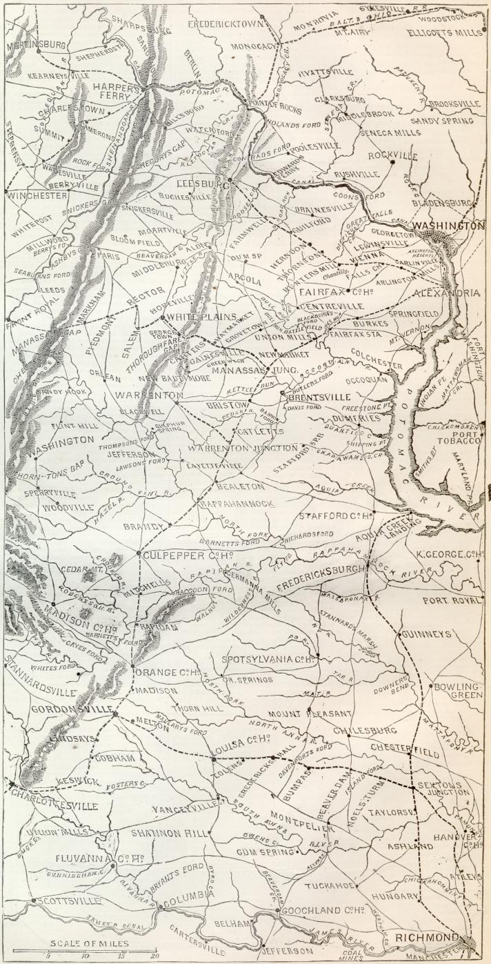 |
||||||||||||||||||||||
|
|
||
|
|
Site Copyright 2003-2018
Son of the South. For Questions or comments about this collection,
contact paul@sonofthesouth.net
|
|
|
Are you Scared and Confused? Read My Snake Story, a story of hope and encouragement, to help you face your fears. |
||