Colton's 1861 Slave Map of Southern States
![]()
This Site:
|
|
|
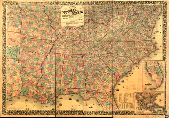
Colton's 1861 Slave Map of Southern States This is an illustration of Colton's map of the southern states, including Maryland, Delaware, Virginia, Kentucky, Tennessee, Missouri, North Carolina, South Carolina, Georgia, Alabama, Mississippi, Arkansas, Louisiana, Texas, showing also part of adjoining states & territories locating the forts & military stations of the United States & showing all the rail roads, Railroad stations, & other internal improvements. Inset Text on the Map:Entered according to Act of Congress in the year 1861 by J. H. Colton. Printed by Lang & Laing, N.Y. "No. 6" in the upper left margin. Insets: Include Southern part of Florida. Colton's map of the United States showing the proposed railroad routes to the Pacific Ocean. Includes tables of population based on the "United States Census for 1860." Cover title: Colton's map of the southern states of America, showing the whole seat of war on the seaboard and in the interior, designating every town, railway, and stream; also showing the forts and fortifications. London, Bacon and Co. Explanations: (i.e., legend) is pasted over the bottom border. Map is colored to show "free, or non-slaveholding states" (pink), "border slave states" (yellow), and "seceded or confederate states" (green). |
![]()
|
Email us at: paul@sonofthesouth.net. Copyright © 2003-2018 Son of the South.
|
|
|
|
Are you Scared and Confused? Click Here to read My Snake Story, a story of hope and encouragement, to help you face your fears. |
||